Know the snow conditions with SNOTEL

Winter has been a roller coaster so far; warm to frigid and now back to warm. Even with the roads in the valley clearing and drying, it is a safe bet that the road into Hyalite will be snow packed and icy. But how much snow and how icy? Will the trails be powdery and pleasant or crusted over and treacherous? Unlike other roads and popular winter recreation areas with webcams and regular status reports (such state highways and ski resorts), it can be a guessing game as to what conditions in Hyalite are really like.
Groups like Bridger Ski Foundation and Friends of Hyalite do some reporting of road plowing and trail grooming, which are done only on a limited basis, meaning conditions can vary widely from what is reported. What was a clear road and fresh grooming on Friday could well be buried under a foot of snow by Saturday morning. Packed snow on the road and powder skiing can quickly transform into a sheet of ice and crusty, hard snow. So what are some resources to give yourself a better picture of what the weather has been up to in Hyalite? Fortunately, there are a couple of government agencies that maintain weather stations that report daily and hourly data to the public on the internet! Skiers will be familiar with the Gallatin National Forest Avalanche Center’s weather page, which serves as a great starting point for all visitors to Hyalite.
This page provides links to data from the Avalanche Center’s weather station on Flanders Mountain as well as to the pair of SNOTEL stations in Hyalite, which are operated by the Natural Resource Conservation Service (NRCS) Snow Survey. With the Lick Creek SNOTEL at lower elevation, the Shower Falls SNOTEL at mid elevation, and the Flanders weather station atop a ridge, there is weather data for most of the elevation range in Hyalite readily available. It is important to note, however, that the data collected at SNOTEL sites is ultimately destined to be used in forecasting water resources and streamflow, so teasing out the desired information as a recreationist can be a little confusing. For a better understanding of SNOTEL data for recreational users, we’ll turn to Lauren Austin, a Hydrologist for the Montana Snow Survey, for a more in depth explanation of what they do and how to read the data.
What is SNOTEL?
SNOTEL is short for snow telemetry, and it is a federally funded network of mountain weather stations. The main goal of SNOTEL is to provide data for regional water supply forecasting for streams and rivers during spring runoff. However, the data is publicly available and is used by a wide variety of groups, including irrigation districts, farmers, municipalities, researchers, and recreationalists.
What does a SNOTEL site measure?
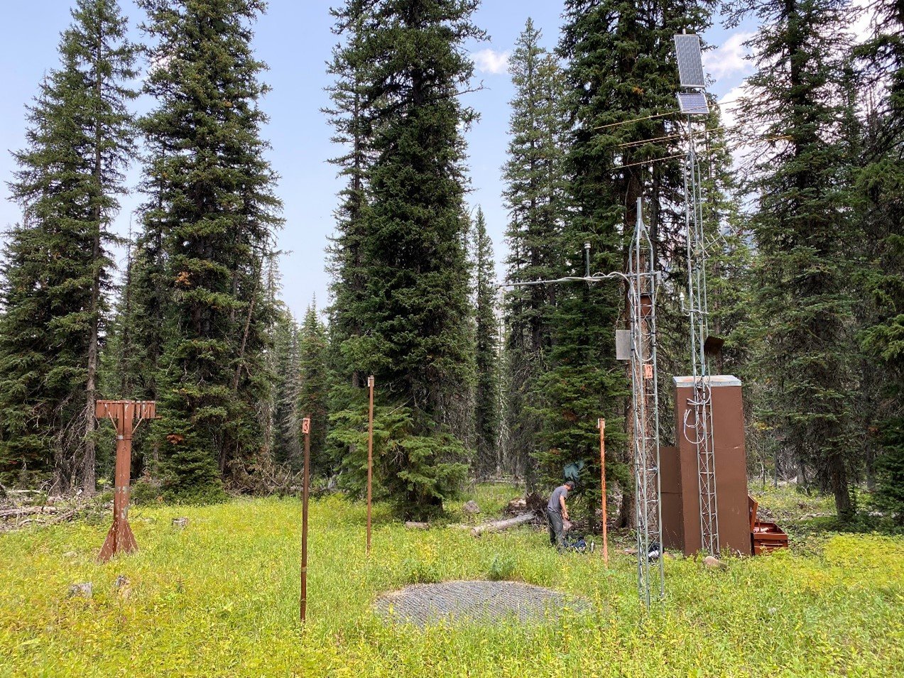
All SNOTELs have sensors that measure:
· Snow Water Equivalent (SWE), or how much water is in the snowpack
· Snow depth
· Precipitation – all forms (rain, snow, and everything in between)
· Temperature
How often do SNOTEL sites report?
SNOTEL sites report hourly. Station time is always in Pacific Standard Time, so a SNOTEL data report reading 8am would be 9am local time during the winter (Mountain Standard Time) and 10am local time during the summer (Mountain Daylight Time).
How does a SNOTEL measure snow, precipitation, and temperature?
· SWE is measured with a fluid-based snow pillow that essentially weighs the snow on top of it with a pressure transducer.
· Snow depth is measured with an acoustic sensor, which sends an audible signal (a clicking sound) down at the ground and measures the time it takes for the signal to bounce off the snow surface and return to the sensor. This sensor often does not perform well during rain/snow because the signal bounces off the raindrops/snowflakes before it can reach the ground or snow surface and gives erroneous readings, which are filtered out automatically.

· Precipitation is measured with a 12ft tall storage gage which collects all rain and snow. Inside is biodegradable antifreeze which keeps the system from freezing during the winter. A pressure transducer reads the height of the fluid.

· Temperature is measured by a thermistor on a 20ft tower. Data for this sensor includes hourly observed temperature, max, min, and average, as well as the max, min, and average temperature from the previous day.
How do I access data?
There are many great online resources for viewing and downloading SNOTEL data. Here are some good ones:
· MT Snow Survey Recreation page is a good place to explore conditions in Montana and Wyoming basins
· Interactive map gives you full control over which parameters you are interested in
· Report Generator is helpful for pulling up any data records (recent or historical) in table or graphical form
Things to keep in mind when you’re looking at SNOTEL data:
· Daily data is reviewed for quality control every weekday by Montana Snow Survey staff.
· Hourly data is raw and unedited, so use accordingly. Pressure transducers (used in SWE and precipitation measurements) can have small fluctuations over the course of a day, particularly on warmer days, so it’s possible to see small precipitation decreases in hourly data.
What should I know about the SNOTEL stations in Hyalite?
Lick Creek SNOTEL was installed in 1963 and Shower Falls SNOTEL was installed in 1965, so they both have data records over 50 years long. If you come across one of these stations, please leave it as it is and take extra care not to walk or ski over the snow pillow, as it collects important data that benefits everyone! We are currently testing several different kinds of snow pillows and other sensors at Lick Creek SNOTEL, so it is especially important not to walk or ski through the middle of the site.
What if I have more questions?
Feel free to contact the Montana Snow Survey via email at MT-nrcs-snow@usda.gov.